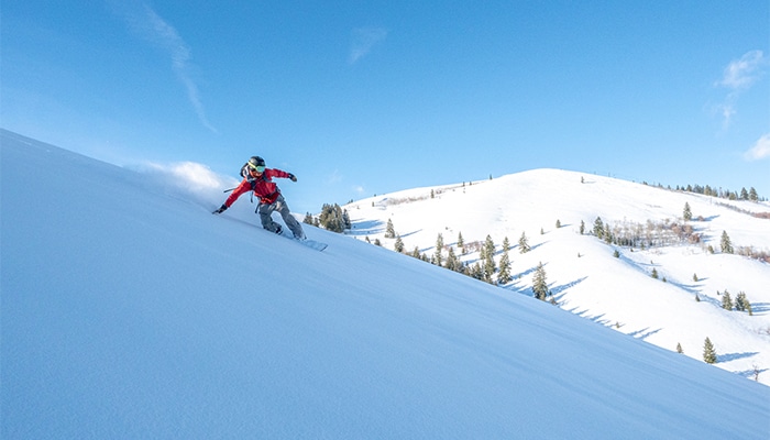
Get Away From Everyone – Backcountry Skiing in Southern Idaho
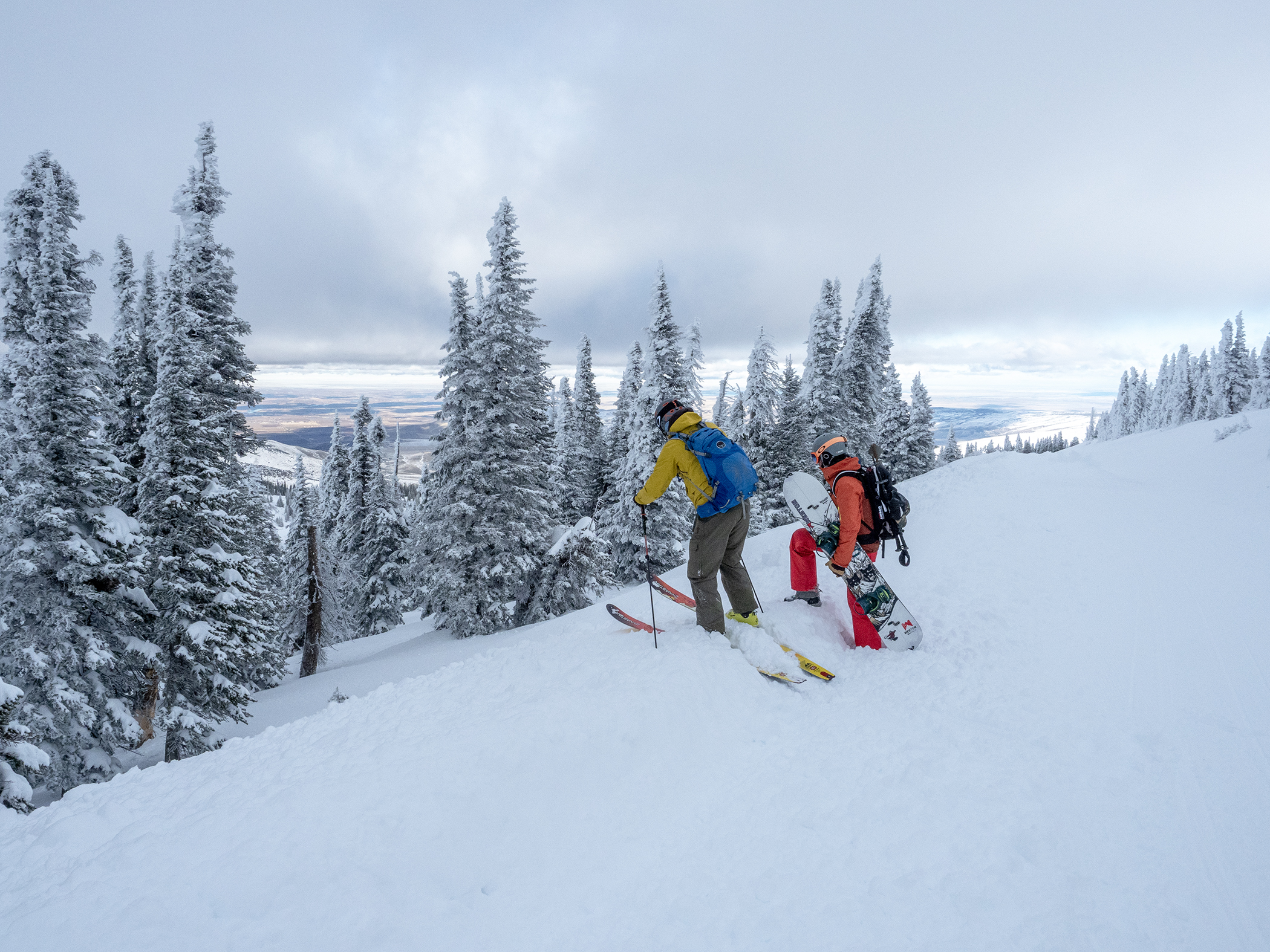
Everywhere you look, the iconic backcountry skiing meccas have become so popular that before you even set off on a ski tour, you probably won’t find parking at a trail head. Let alone untracked snow. For those seeking to make the first timid step outside of their local mountains or yearning for tens of thousands of acres easily accessed with only a handful of others, look no further than the mountains in Southern Idaho.
Here’s Local Freshies advice, guides, and backcountry skiing maps in Southern Idaho.
Mountains Are Dangerous In Winter
Before venturing into the great unknown, be aware that backcountry skiing comes with risks that you must be aware of. When you play in the mountains in winter, avalanches aren’t a probably but a reality. Once you pass the ski resort’s boundary, it’s up to you to be prepared. This means having a first aid kit, taking an avalanche education course, and traveling with avalanche gear.
Not Just Avalanches
Besides avalanches, there are other inherent risks of being in the wilderness you also need to be prepared for. We had a rude awakening on our 1st backcountry tour by having someone break their leg. Did it stop us? No. Instead, we learned from our experience and made sure we were better prepared moving forward.
Where To Get Gear Locally
In addition to all the fun gear such as climbing skins and split boards, from an avalanche safety perspective you should ALWAYS carry a beacon, shovel, and probe. It’s critical that you know how to use them and are well practiced in case a snow safety incident occurs. Locally, you can pick up these crucial items along with other backcountry gear from the Magic Valley Gear Exchange.
Gear Is Important But Education Is Even More
Safety equipment is like an airbag in your car. It’s used only AFTER you get caught in an avalanche. More importantly to make sure you reduce your risk of getting caught in an avalanche in the 1 st place, get an Avalanche Education. And when it comes to backcountry education, the gold standard in the United States is A.I.A.R.E. It stands for American Institute for Avalanche Research and Education. Think of them as the equivalent of the American Medical Association but about avalanche safety. There are many locations that provide certifications from ski resorts to community colleges as well as private outfits. And each one provides something special or unique. In southern Idaho, the closest providers are the Sawtooth Mountain Guides and Selkirk Powder Guides. To find one near you, visit the AIARE public course list.
Get The Forecast. Having the right tools and education lays the foundation, but it’s applying what you learn in real life that’s key. Before you even step outside, be sure to read the avalanche forecast and plan your outing accordingly. Throughout the ski season for the Southern Idaho mountains, the Sawtooth Avalanche Center puts out a daily report around 7 am MST. Specifically for the areas we list below, you should focus on the Soldier & Wood River Valley Mtns region. In it, you’ll find where the latest avalanches occurred and what avalanche problems exist. This will help you in figuring out where to ski, not ski, or on certain days to just stay home. If you’re curious on what the other avalanche centers are across the nation, visit Avalanche.org.
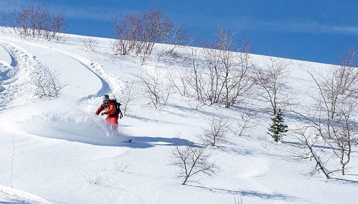
Magic Mountain – Perfect For First Timers
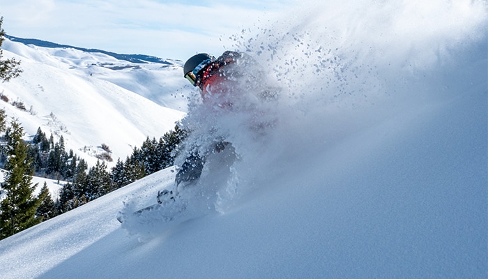
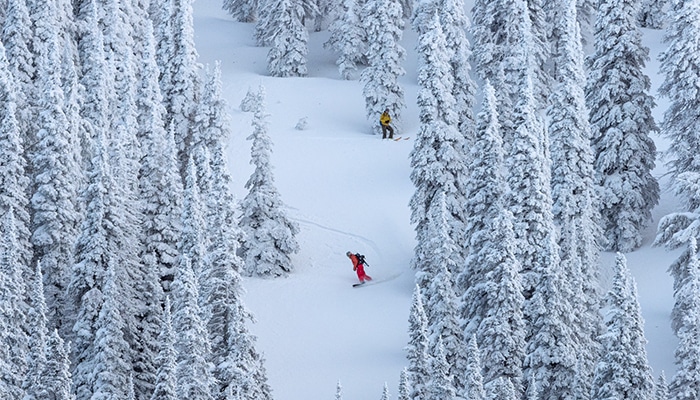
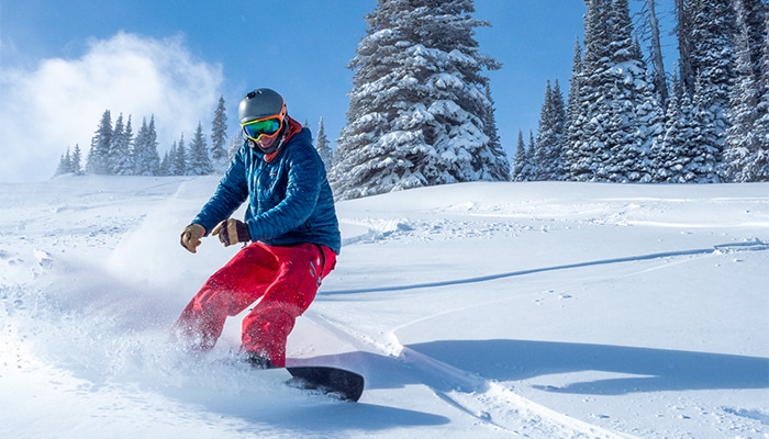
Only an hour away from the rolling plains and the iconic Shoshone Falls in Twin Falls, Idaho, you wouldn’t think there would be snow let alone anything decent to backcountry ski. You’d be wrong. While Magic Mountain ski area isn’t high in altitude, it does get more than 200 inches of snow annually. On top of it, even if it’s warm in town, the snow preservation is incredible. You won’t find puckering steeps or rowdy couloirs. What you will find is tons of quick touring options filled with plenty of hippy pow to slay. All this combines for a perfect place to make an introduction to backcountry skiing.
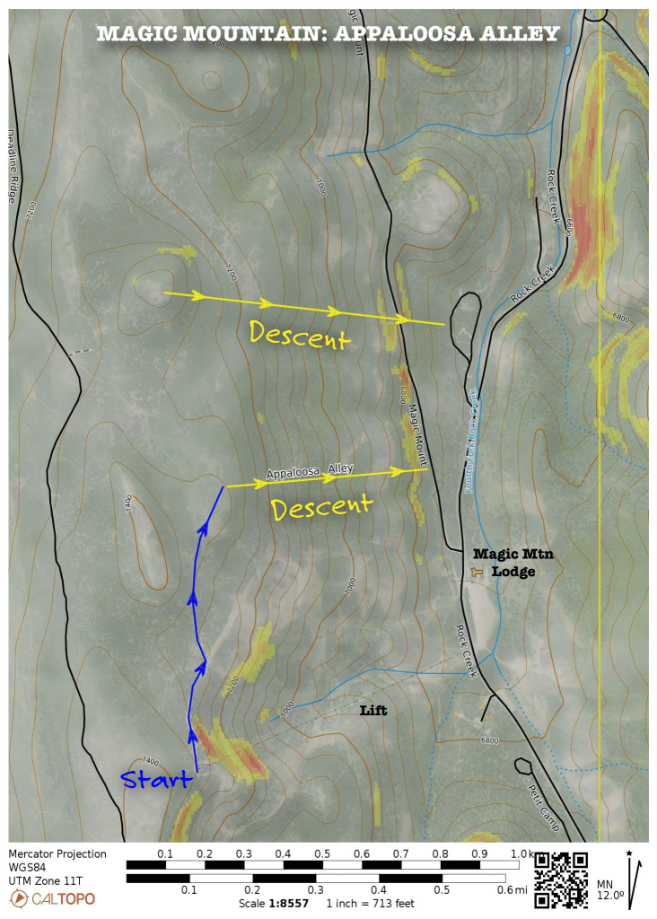
Appaloosa Alley
Magic Mountain Ski Area like many other ski resorts in Idaho is situated on a ridge-line. The resort frowns upon people heading to the south of the ski area since the ridge-line gets wind loaded with huge cornices. But to the north, you’ll find several 400’ – 700’ vertical shots depending on how much or little skinning you want to do.
The Route
Take the double chair to the summit. From there, follow the Spell trail along the ridge-line until it begins to veer to the right. There you’ll see on your left, a small trail sign for the Elk Basin Cross Country trail. Here you’ll want to transition to your skins.
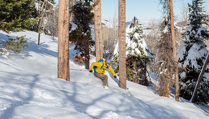
The route gently ascends and in a quarter mile, you’ll reach the old poma lift tower. You can continue further north along the ridge-line if you want longer shots. Or if you wish to descend, you’ll find a few avenues that allow you to ski through aspen groves. At the bottom, you’ll come upon a groomed route that is the 500 road. Once there, you can push your way back all the way to the ski resort for as many laps as your legs can take. Word of caution: If you do descend past the road, you can get in a few more turns but be aware that Rock Creek is at the bottom making it nearly impossible to get to the road.
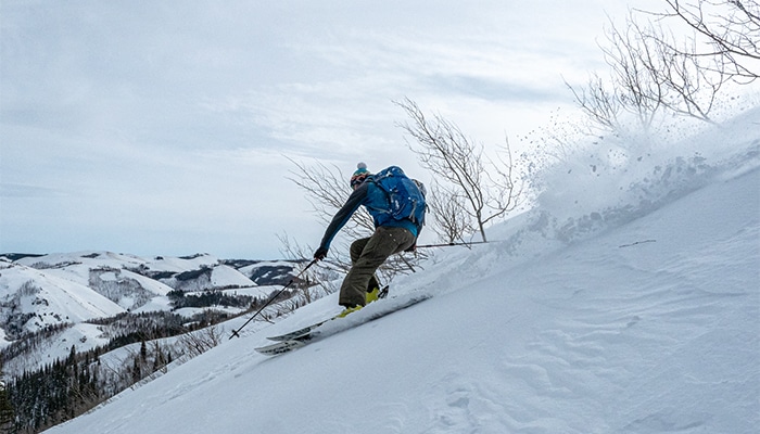
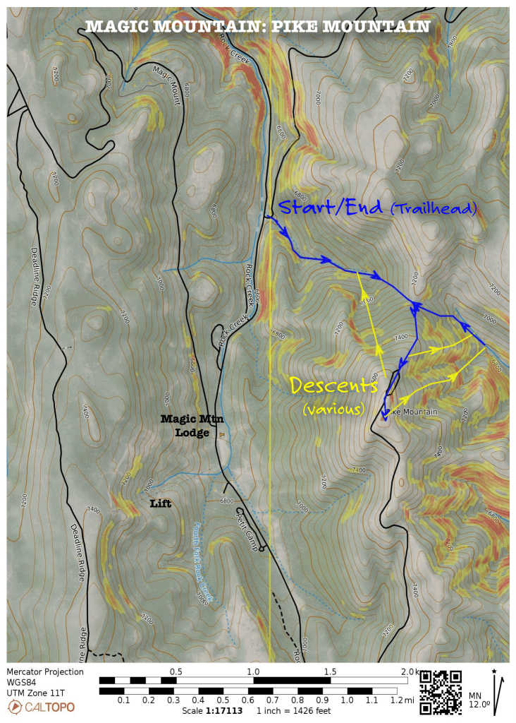
Pike Mountain
The prominent peak to the east of the ski area is Pike Mountain. From the lift, the treeless west aspects of it are where many locals learn to backcountry ski. For an authentic ski touring experience, the north and east flanks of this mountain are where it’s at. For those who put in the work, you’ll find a smorgasbord of terrain you can yo-yo laps to your hearts content.
The Route
Drive a little more than ¾ of a mile north from Magic Ski Area to the Wahlstrom Hollow pull-out located on the east side of the road. Park here and take the Wahlstrom Winter Rec Loop which is a well-marked route with blue arrows. It follows the creek drainage until it begins to zig zag its way up to the bench. From here, you’ll want to follow the northeast flank to the summit of Pike Mountain.
From the summit, you’ll find north and east bowls with low to mid angle terrain. There is quick 600’ vertical shots filled with oodles of powder. And if you’re lucky enough to be there when the wind isn’t blowing, the terrain opens up even more allowing 1,200’ vertical descents.
After you’re finished skiing, you have two options. Skin back up to the saddle where you can follow the route down back to your car. Or if you wish for additional turns, skin back up to the summit and ski the northwest glades off of Pike Mountain back to your car. Be aware that the lower sections of the northwest face can get a little ‘bushwacky’.
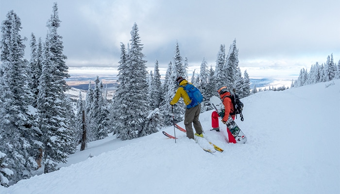
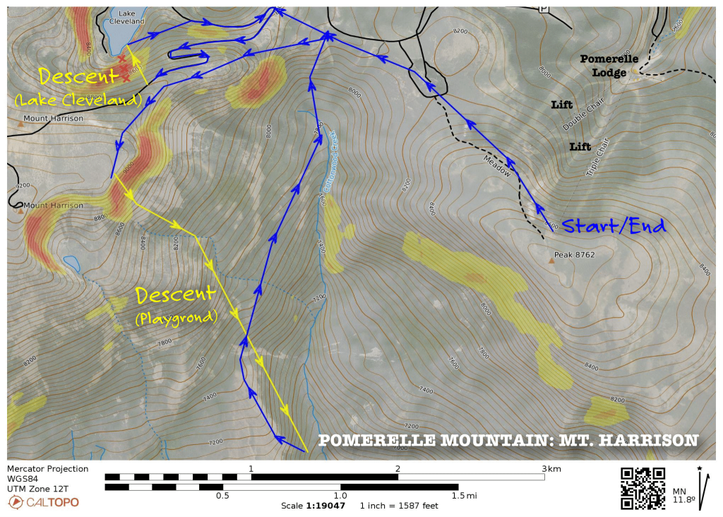
Pomerelle Mountain – A Variety Of Terrain
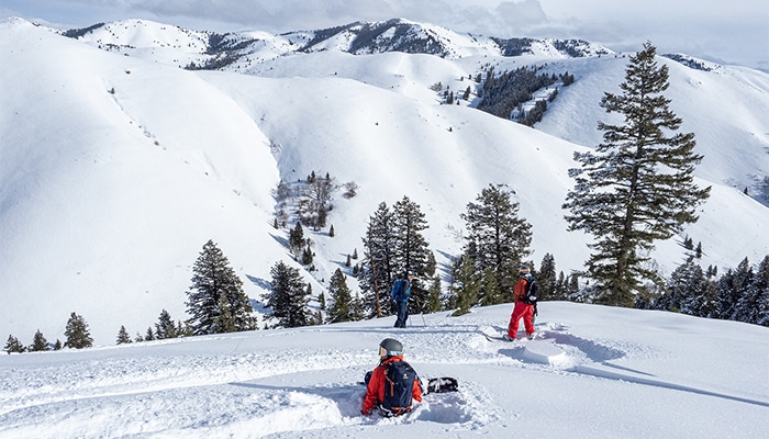
Pomerelle Mountain and the surrounding backcountry is a powder hounds dream with these peaks averaging 500 inches of snow annually. With the ski area as your base, you have an assortment of mellow glades up to some rowdy chutes to pick from. And those who are serious ski touring adventurers, both Cache and Independence Peaks to the south top out at 10,000 feet and are fun to explore if you’re willing to snow camp.
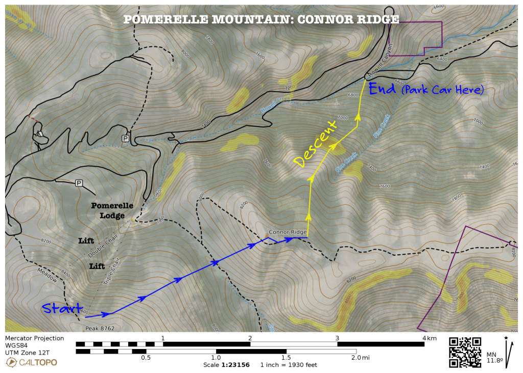
Connor Ridge Shuttle
On the ridge-line to the northeast of Pomerelle, you’ll find up to 1,600 vertical feet of low angle tree skiing with an easy skin from the resort. While there aren’t big steep avalanche paths, route planning comes into play for this because of how dense the forest is. Picking your avenues of descent is crucial to make it enjoyable.
The Route
To ski this route, you can either shuttle or start at Howell Canyon trailhead. Either way, you’ll end up at the Howell Canyon trailhead. First timers, we recommend starting at Howell Canyon so that you can route plan your descent as you’re climbing up.
Shuttle option: From the top of the triple chair, you’ll want to head skier’s right to Barry’s Run. From there, follow the trail and keep veering right as much as possible. As you pass the ski area, continue descending northeast until you reach the creek drainage. Here you’ll want to transition onto your skins and begin the climb. Ascending northeasterly towards the top of Connor Ridge. From there, you’ll want to follow the ridgeline easterly using the trees as a wind break for about a third of a mile. To your north, you’ll come upon an area where tree cutting is in progress. This is where you’ll want to begin your descent.
Howell Canyon option: Approximately 3½ miles down the canyon from Pomerelle Mountain Road you’ll find the Howell Canyon Trailhead, located in the creek drainage right after the house that sits on the switch back. Starting here, you’ll cross the road and ascend southwesterly through the trees until you hit upon a snow-covered dirt road. Follow this for about a third of a mile until you come up to the first large clearing. Ascend southwesterly and follow these clearings while zigzagging your way to the summit.
Descent: As you begin to descend, be acutely aware that you do NOT want to be lured into the gully to your skier’s right. We ended up getting in here and it became VERY bushwacky. Ski the knuckle of the ridge-line which will start out north and become northeastern as you hit the rollover. From here, continue skiing fall-line until you hit a snow-covered road following this out until you reach the road.
Where to Stay to Ski Pomerelle
Mt. Harrison
From the parking lot of Pomerelle Mountain, you wouldn’t expect to find big and burly terrain. But just due West is Mt. Harrison. This peak offers an incredible amount of terrain to suit anyone’s tastes. Big open bowls, moderate pitches with perfectly spaced glades, rowdy chutes, incredible snow preservation, and so much more. If this peak was in Lake Tahoe or another popular backcountry region, people would flock to it. For this area, be aware of snowmobilers who don’t ride the terrain quite like skiers do. Stay alert to your surroundings.
Tip: If you do hit up the Mt. Harrison/Lake Cleveland area, check in with ski patrol first. Once you go over the ridge, there is NO cell service, and this is serious big mountain terrain. Have a plan on how to exit if you do run into trouble.
The Route
There are two options to access Mt. Harrison. You can park at the snowmobile parking area just up the road from the resort or use the lifts to gain quick elevation and reduce the approach.
Snowmobile Parking Lot: From here the approach to the summit is about 4 miles. The navigation is easy since you’ll essentially follow the groomed snowmobile trail that is known as Howell Canyon Road in the summer. Approximately 2.5 miles up the road you’ll come to a fork. To the right gives you access to Lake Cleveland. This would be your exit after you’re done for the day. For the summit and the rest of the ski opportunities from this intersection, you’ll want to head left.
Pomerelle Ski Resort: From the top of the triple 88, head skier’s left (northwest) following the ski area boundary as much as possible. Keep up your speed and once you’ve come to a halt, you’ll transition to your skins. From here, follow the ridge-line making sure not to descend into the bowl on your left. Using the shoulder of Mt. Harrison, begin your ascent towards the peak.
Lake Cleveland Descents: From the top of Mt. Harrison to Lake Cleveland, there are a variety of lines to choose from. If tree skiing is what you’re after, the north facing terrain to your right is filled with perfectly spaced trees and a moderate pitch that all drop down into the lake. This is a great first descent to get eyes on all the terrain available. One word of caution: There is a HUGE gnarly cliff skier’s left that you will want to avoid. It’s approximately a mile up the road and can easily be avoided by veering right from the top. Once done for the day, follow the road back the same way you came in.
The Playground Descents: The east side of Mt. Harrison is affectionately nicknamed The Playground. As you crest over the ridge-line and see it with your own eyes, you’ll understand why. The terrain is filled with chutes and cliff bands that any serious skier would enjoy. These can be accessed by following the shoulder of Mt. Harrison instead of the road. When these are in play, you can have runs up to 2,500 vertical feet of descent. Be aware the further you go down, the longer the up is to get back to the ski resort and return to your car.
Soldier Mountain
Despite being only an hour away from Sun Valley, the Soldiers are primarily off the radar for most backcountry skiers. If you do make the journey here, you’ll find a cornucopia of options to ski. Instead of slopes of dense forest, the rolling mountains are sparsely covered in vegetation. The only trees you’ll find are in the sinewy valleys and more protected aspects. This in turn gives you the option to ski any aspect and find the perfect snow for that day. Check out Local Freshies personal experience backcountry king at Soldier Mountain: https://localfreshies.com/backcountry-skiing-soldier-mountain/
Above Soldier Mountain
There are numerous larger ski objectives above the ski resort such as Peak 1, 2, 3, and Smoky Dome that top out at a whopping 10,100’. It has several areas steeper than 30 degrees, so avalanches can go BIG in this area. This is also where Soldier Mountain’s cat skiing operation primarily exists. It’s frowned upon to ski the terrain inside their permitted cat ski boundaries. Rather, if you do want to ski above the resort, be sure to reach out to ski patrol so they can give you guidance on what you can or cannot ski.
Bridge Creek
Bridge Creek is a massive zone that runs parallel to the rest of the ski area and is accessed from the top of Bird’s Eye lift. An extension that’s wild and home to funky topography that’s playful and yet not extreme. Its surfy slopes feature 600 vertical foot shots that you can yo-yo to your hearts content. It’s a perfect introduction to backcountry skiing. The trails in this backcountry zone have been named after classic 80’s films.

The Route
To enter, ski patrol asks for all visitors to check-in first at the hut at the top of Bird’s Eye Lift. From there, you’ll exit the resort and ski due south. You’ll pass a handful of snow fences and come to a drainage. From here, you’ll put on your skins and begin the climb continuing south. Keeping the ridge-line to your right, focusing on not losing elevation as you zig-zag your way up to the knuckle that’s due south. Curving around the knuckle, you’ll come upon a southern open bowl which is known as Die-Hard. If you continue skinning up to the highest point another hundred vertical feet, you’ll get another three turns hence this section of the bowl is called Tri-Hard. If you do ski Tri-Hard, be aware that to skier’s right there is a little roll-over where youcould trigger an avalanche. Ski until it flattens out.
From the bottom of Die-Hard, you’ll want to transition and begin your climb up the drainage to the right of the way you came down. You can ski another lap on the same face or curve northeasterly to the ridge on your right. This slope is called Nakatomi Plaza which will finish in the same bowl. You can continue yo-yoing this same drainage as far as you want.
Exit: Depending on how you want to exit, you have a few options. The first and most challenging is to skin back up from whence you came and to the top lift. The second is to hit one of the many north facing shots. The last and most creative is to make it a full ski tour – Goonie’s Ridge. Following the ridgeline, you slowly meander and follow the ridge that makes the backbone of the Bridge Creek area. Then to exit from Goonie’s Ridge, you’ll look for the 2nd tree opening which has been affectionately called Monkey Crack. From there, you’ll follow the creek until it spits you out right into the parking lot.
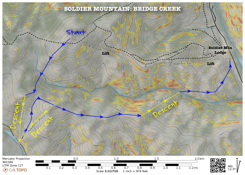
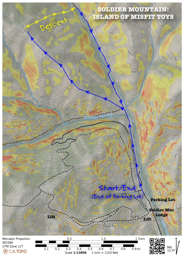
Island Of Misfit Toys
Another option that is easily accessible from the resort is to head to the area north of Soldier. Nicknamed the Island of Misfit Toys, the ridgeline has a variety of 1,000’ vertical shots with plenty of open with moderately pitched bowls and things to jump off. The views of Soldier Mountain Ski Area and the surrounding peaks are worth the effort. This area does have a variety of pitches that are steeper than 30 degrees (i.e., avalanche terrain) and can go VERY big. Careful route planning is a good idea on days when there is a persistent slab.
The Route
Starting at the north end of the parking lot, you’ll follow the groomed snowmobile trail. About ¾ of a mile look for the blank brown sign which is used for summer camping info. Follow the ridgeline northwesterly. As you quickly gain elevation, you’ll be provided with views of Soldier Mountain Ski Resort and the cat skiing operation in the distance. Be aware that both snowmobilers and backcountry skiers share the same ascent but enjoy different terrain for their descent. On top of this ridgeline, pick from a variety of slopes to descend east. To exit, follow the creek back the way you came keeping it on your left side.
Check out all of Local Freshies amazing adventures on their website: https://localfreshies.com
Where to Stay?
Coffee Shop in Fairfield
Fly to the Magic Valley
Fly to Twin Falls for an easy and convenient trip. The flight takes less time than it takes to bake a potato from Salt Lake City! Plus, it shaves off a long 3 hour drive that usually has bad road conditions through winter. Flying into the Magic Valley Regional Airport makes life easy because it is small. Once you exit your flight, baggage claim takes minutes, then you can walk out the front doors. No long terminal walks, no dodging loads of people, just a quiet airport taking you straight to your destination. Get your flights here: https://iflytwinfalls.com