Cache Peak Backpacking by Jon Conti
The Beginning of the Journey
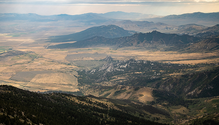
It’s 6:00am and the sun is rising over farmland off in the distance. It isn’t until you’re above it that you appreciate the agricultural beauty of Idaho. In the valley below are rolling hills of green patches, dotted with farmhouses. On either side, the Albion Mountain Range frames the landscape. The sun creeps over the peaks turning a bright orange and red as it meets the thick clouds rolling in. A chill is in the air on this last day of August. I pull my backpack out of my car and check to make sure my rain gear is handy.
I camped at Independence Lakes Trailhead the night before so I could get an early start this morning. The road up to the trailhead at 7,760’ wasn’t in great condition and I did not want to be trying to navigate it in the dark. Taking in my surroundings in the morning light I’m surprised to see a well developed camping area. There’s a big parking lot with a bathroom for those not wanting the full “into the wild” experience. Between the parking lot and the trailhead is a little stream with a nice wooden bridge over it. Across the bridge is a campground equipped with a picnic table and multiple areas for tents and fire pits. Through the campsite is the trailhead, and the start of my journey to Independence Lakes.
Hiking to the Lakes
It’s roughly 3 miles and over 1,000′ to the first of four lakes that sit under Mount Independence. Wait Mount Independence, isn’t this about climbing Cache Peak? Until this journey my sole focus had been to climb Cache Peak, blinding me to the fact that these lakes don’t sit under one mountain but between two, creating one of the most stunning hiking destinations in all of Idaho. But I’m getting ahead of myself, first I had to get there. The first two miles of the trip see a nice variation of terrain and views.
You start in a thick aspen forest following the sound of running water over large rocks and small streams that have found their way onto the trail. About a mile into the journey the forest opens and I’m standing on an open hillside overlooking the farmland I had seen earlier. Thick sagebrush blows in the wind, replacing aspen trees. I peer up to where the sun should be beating down on me and the exposed hillside. Dark clouds have blanketed the valley, and though I appreciated them keeping me shaded and cool, they did appear to be carrying rain. Something I had been hoping to avoid.
2 miles into the trip sees the trail move back into the forest. Until this point the hike had been an easy stroll across the hillside. Suddenly the trail gets steep. Switchback after switchback appear as my lazy hike turns into an actual climb. I knew my final destination at Cache Peak was at 10,339 feet. The next mile was a forest fully enclosed around me, views of only trees and deadwood.
Arriving at the Lakes
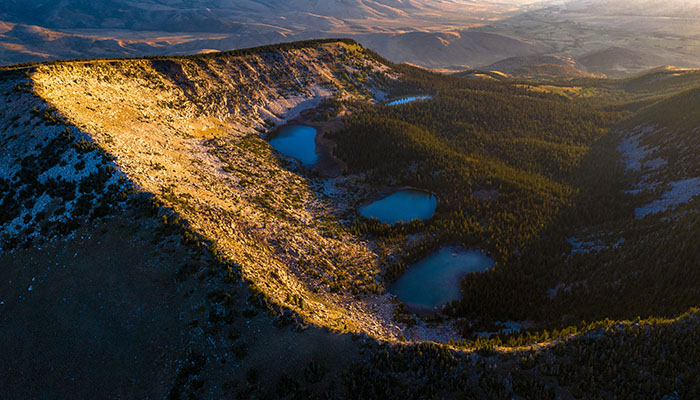
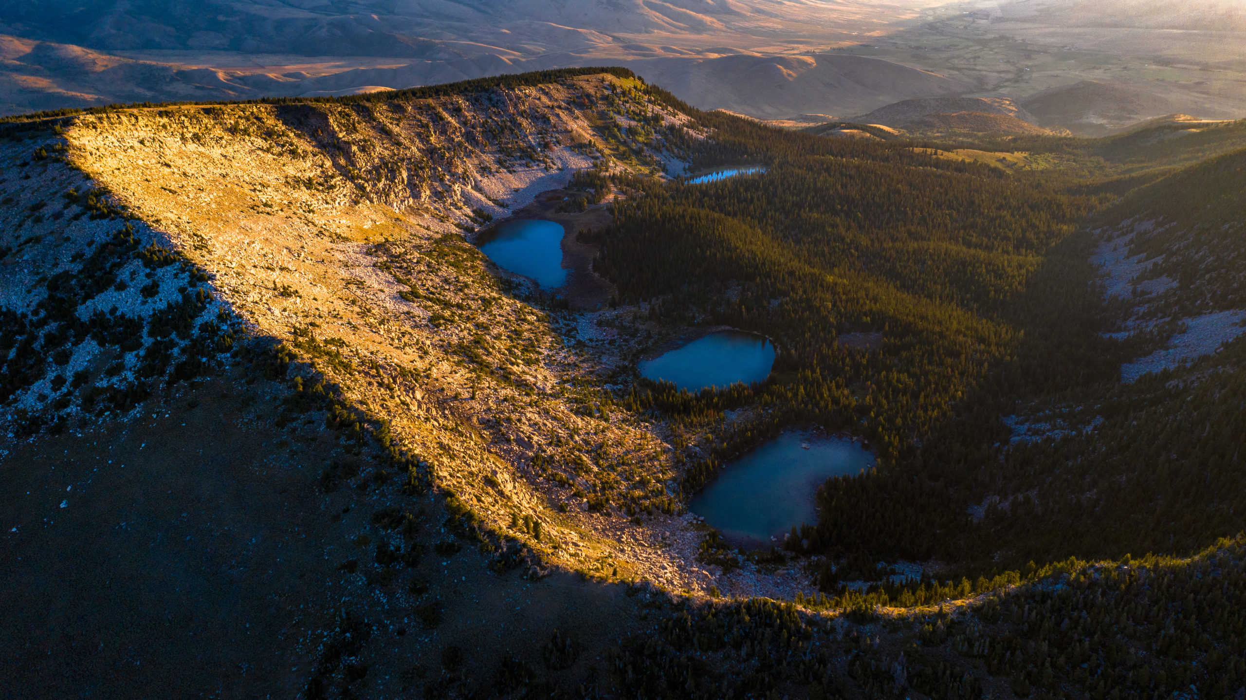
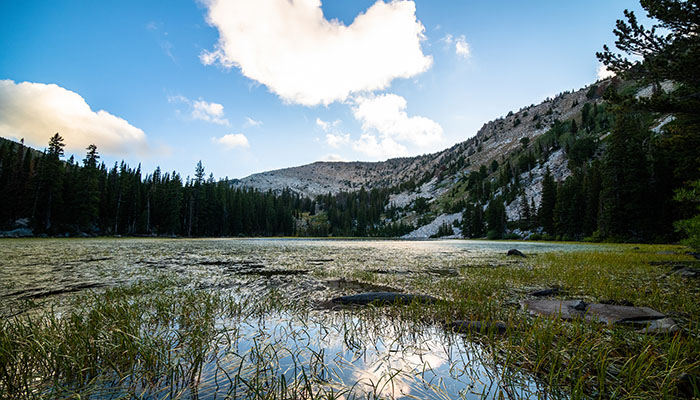
After a mile of vigorous climbing the trail levels and the first lake appears. Walking to the edge is a gorgeous view of blue water, Mount Independence sitting directly behind. There’s a large campsite here and I think about dumping the pack to make camp. The clouds rolling in have become dark by this point, rain wasn’t in the forecast but I’m certain it will come.
I decided to get up to the second lake and see if I could find a more secluded spot. I cross the creek outlet at the first lake over some deadwood and pick the trail back up on the south side of the lake. Here I find many more campsites and if you are looking to set up camp at the first lake I would definitely recommend doing it after crossing the outlet. At the end of the lake the trail climbs a little bitt, and looking back you get a great view of
lake #1 in its entirety.
Lake #2 is a completely different look. It sits up against Mount Independence and instead of being covered by trees, the shoreline is made up of big granite rocks surrounded by marsh grass. There is a distinct clump of trees sitting in the middle of this more barren terrain which immediately grabs my attention. Upon arriving at the little grove, signs of camping activity are abundant. Intricate fire pits, flat dirt surfaces for tents, logs and benches cut out of fallen trees. This is my spot. I make camp and take in my surroundings.
Cache Peak Backpacking
If you only hike to the first lake, you really won’t get the full picture of the basin. But at lake #2 you’re finally above the thick forest and you can see clearer what is around you. To the west is Mount Independence and its sheer cliff wall, and to the south you are finally able to get a good view of Cache Peak. Unlike its counterpart, Cache Peak is covered in green firs instead of the sharp opaque rock on Independence.
I needed to consult my notes to make sure I was right about which mountain was which because from this spot, Independence looks like the taller mountain. But at 9,950’ Independence is roughly 400 feet lower than Cache, and of course you want to be able to say you climbed above 10,000’ right! Rain begins to drizzle. I throw on my rain gear and set off to climb another 2,000’ to the top of Cache.
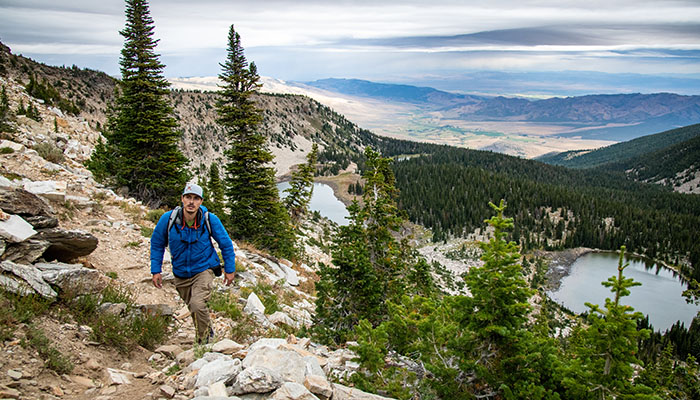
I’ve shed my heavy backpack for a light day pack and start back up the same trail that brought me here. Lake #3 is a stones throw from #2 and the smallest of the lakes. At the far end I do some exploring and find several secluded sites among green grass and wildflowers. If lake #2 is occupied, this would be my second choice to make camp. The trail turns before the fourth lake and though I’d love to explore it, I just don’t have time. The rain is steady now and I still haven’t started moving up, until now. After the third lake it’s all up.
You start across the side of Mount Independence heading east before a switchback turns you around and points you southwest towards Cache. It’s not that far to the saddle between Cache and Independence and from here you get the best view of Independence Lakes and the area in general. Two 10,000’ mountains on either side of you, 4 lakes below you, in the distance you can see the valley and it’s farmland, the Albion Mountain Range leading your eye off into the horizon.
For many, this will be the end, and if you’re only doing a day hike I recommend getting to this spot at least. The view at lake #1 is great, but this is one of the best views in Idaho. If you turn around and peer west you will see City of Rocks in the distance, a completely different view but dramatic in its own alien way.
The Storm
And here is where my journey gets interesting, it has begun to hail. My options are to climb Mount Independence which always seems closer than Cache Peak. From where I stand in the saddle I can clearly see the summit for Independence while Cache Peak still hides off in the distance. Ideally I would do both, and if I wasn’t trying to shoot pictures and a video in a hailstorm that would’ve been my choice. But I have limited time left and the weather is getting worse by the minute. I still don’t exactly know where the summit is.
I decide to continue following the trail, heading south towards Cache. This was a mistake, and one that almost cost me the summit. From what I’ve read since, the trail I’ve been on this entire journey is an old ranger trail that continues down and around Cache from the saddle. About a half hour into following this trail I make the decision to go back. I was quickly losing elevation in a troubling way. I didn’t know exactly where the summit was, but I knew it wasn’t down. Back at the saddle I’ve lost precious time. It’s 4:00pm and the wind is howling. So much so that if I set my camera up on it’s tripod I have to weigh it down with rocks to keep it from blowing over.
Hail is now beginning to blow sideways, stinging me in the face, and my shoes and socks are soaked through. I set a timeframe for myself, if I haven’t reached the peak by 6:00pm I’ll turn around. Getting stuck in the dark on the side of a mountain in a hailstorm was not how I wanted to spend my night. So with that I begin to bushwhack from the saddle. The hail has turned to snow and the wind becomes more intense the higher I go. With more time, better weather, and less camera gear it probably would have been a fun little scramble through fir trees and big mountain boulders. But the snow made the rocks slick, and any sign of a trail was lost to the elements.
Summiting
I climb for about an hour ending up on the west side of the mountain. From here I have an incredible view of City of Rocks, and above me I can see the summit. It took me about 15 minutes to set up my tripod for a picture on top of Cache Peak. The wind was blowing me sideways, and it took some core strength to stand upright. But there was a break in the hailstorm and I was able to take in a stunning view overlooking City of Rock and the rest of Southern Idaho.
I let out a howl and a triumphant yell. Perhaps this angered whoever was listening because as soon as I did the weather got worse. Snow began to fall and I was engulfed in dark grey clouds. Some worry set in. It was 6:00pm and light was fading fast.
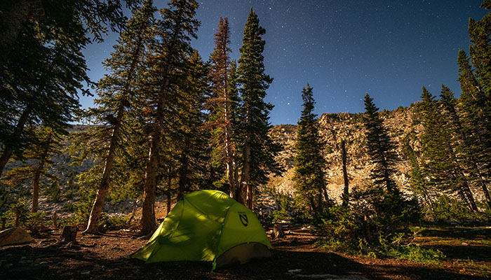
Like a mountain goat I raced back down to the saddle, and as soon as I crossed over into the basin, the wind stopped. Almost like the mountains watch over the lakes protecting them from the storms. I make my way back to camp on the last bit of daylight left. Soaked, I strip down and tuck myself into my sleeping bag. I set my alarm for 2:00am, you never know the clouds could clear, the stars could come out, and it would make for a great time-lapse. At 2:00 I shyly peak my head out of my tent. It’s calm, the wind has stopped and there’s not a cloud in the sky. The moon is out, illuminating the basin in bright light. I set up my camera and enjoy the stars for as long as the cold will allow me before jumping back into bed.
The Morning After the Storm
The next morning I’m greeted by a beautiful sunrise and blue skies. I start a nice fire to help dry out my clothes and shoes. I brew a strong cup of morning Joe and sit next to the fire. My bare feet warm on a nice log stool made by an adventurer before me. I let the morning wane, I have no where to be. I pack up camp, put on my now dry shoes and walk down to the lake. Fish are jumping, should’ve brought a pole. Slowly I make my way back to my car and the trailhead.
Everything looks new covered in the morning sunlight. On my way back I pass an old timer heading up to the lakes with a full pack on his back. It’s a moment out of the twilight zone, like I’m passing an older version of myself. A wiser more patient Jon, one that knows to wait for the dark clouds to pass before climbing mountains, the sun will come out eventually.
Check out more of Jon’s adventures on Youtube and Instagram!

YouTube: youtube.com/c/theadventuresofjonchad
Instagram: jon_conti